
dengan nama ALLAH yang maha berkasih sayang
Chedorlaomer... King of Elam, or Kedor-la'omer in Hebrew. Mentioned in Genesis 14, as one of the Kings of the Four Corners of the Earth... was considered the Powerful King of the East and a contemporary of Abraham-Brahma, whom the later saved his brother
Oddly enough, no known Elamite King
bears the name Lagamar, the god for which Laomer, as in Chedor-Laomer is thought to be named after. One reason for this is that Laomer could mean, 'of Elam' or 'from Elam', the same Ilam that is in the extreme east within the modern boundary of Nepal-Naphtali which separates it from Sikkim-Shechem and the title for which the Lama order of Priest-Kings may owe their name.
Every year at a certain time among all of the festivals that are held in
In the New American Standard version of the Old Testament of the Holy Scriptures, Exodus 19:16, quoting: "So it came about on the third day, when it was morning, that there were thunder and lightning flashes and a thick cloud upon the mountain and a very loud trumpet sound, so that all the people who were in the camp trembled."
Numbers 29:1, quoting: "Now in the seventh month, on the first day of the month, you shall also have a holy convocation; you shall do no laborious work. It will be to you a day for blowing trumpets."
Go To: www.godkings.com/biblekings.txt
Another installment for the script of GODKINGS the Movie is this:
Our Studio is going to create a prop that exploits the technical aspect of piloting the Flying Saucer-Chariot Stupa by giving the audience a focal point within the captains bridge. This focal point is a visual prop which is a kind of transparent version of the Ship itself and strategically placed in the center of the bridge's control room with a holographic duplicate of the ships magnetic drive as it interacts with the Earths geomagnetic field, like a set of Freznel interference patterns or so called Newton Rings. The purpose of this mechanism is to give the audience a point of reference for the flight capabilities of the vehicle without detracting from the drama or dialog of the actors; and without the need for constantly reinforcing the external visual environment of the Saucer-Chariot. At the same time a bright colored ring representing the plasma drives interaction will be placed at a position floating just below the lower hull of the ship at almost the diameter of the base of the saucer itself. This is a very dramatic addition to the visual aids of the Movie GODKINGS. Alex and I hope you like it...
Our movie opens in ancient history, with Lord Manjushri landing his flying chariot-stupa on Swayambhunath hill in the Kathmandu Valley of Nepal... after which he fires a powerful particle beam weapon, blowing a hole in the mountain valley wall, draining the Naga-Ra Lake and creating the Chobar Gorge in advance of the arrival of Lord Yehovairocana in the Boudhanath Stupa. Next, we can see the tiny bright spot of our sun in the center of our solar system as we are looking from the inside out... right through the hull of our Lords chariot-stupa. As his vehicle approaches the inner planets we are allowed a god's-eye view of the magnetic lines of flux or pulley belts acting as Gravity II Standing Radio Emissions connecting all of the planets to our sun as they sweep along in their orbit through space... our Lord's chariot now begins to approach earth and the gravitational pully belt structure becomes more defined and also the role of the earths geomagnetic field along with the auroral ovals as the electromagnetic propulsion of the Boudhanath chariot begins to interact with the geomagnetic field of our earth etc.
I've decided to publish some more of the ideas for the script. There is always room for interesting humor...
We are going to take advantage of some old cliche's. You may see one or all of these old sayings represented in high resolution graphics. For example: For "Money Talks", you might actually see money talking... or it might actually be "Raining Cats and Dogs" or even cattle... that's right "Cows" or someone having a cow, NO NO, not the last one. This is just a sample.
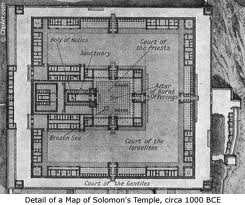
Oh yea... one more interesting fact about the Solomon Temple comes from, I Kings 7: 21, quoting: "He set up the pillars at the vestubule of the temple; he set up the pillar on the south and called its name Jachin; and he set up the pillar on the north and called its name Bo'az."
Since the "New West Minster, Dictionary of the Bible" states that the pillar of "Jachin" is on the "right-hand" and the pillar of "Bo'az" is "the one on the left or n. side, set up in the vestibule of Solomon's
This means that the House that Solomon built; had to face West... just like the Temple of Angkor Wat, built by King Suryavarman II, in Cambodia-Judah.
Since there are twelve Cheribum-Prangs comprising the
Some of the landing sites for the chariots of our lord will be revealed...
One example may be Borobudur on the
I had originally obtained the idea for the
THANK YOU!
A rough Quicktime preview can be viewed by clicking on: movie@godkings.com at the left on this page... it takes about 60 seconds to download using a T-1 line so please be patient "IT WILL WORK". The next installment to this video preview will include the electromagnetic torus field expanding outward from under the hull of the saucer and emerging from the strobing "windows" at the base by disintegrating the paint and white wash covering the "STUPA", it's mount and causing the eyes of Bodhanath to cry and melt the paint like eye make-up running in the rain... like a "grass fire" line burning in a field and allowing the high polished gold dome of the "STUPA" to be revealed-like a butterfly emerging from a cocoon or a snake shedding it's skin. Alex and I hope that you like this effect. I created it for "GODKINGS" the movie.
A larger Image may be found at: "www.godkings.com/lg.jpg".
Other interesting views are at: "www.godkings.com/wire.jpg"
"www.godkings.com/stills.jpg"
"www.godkings.com/flg.mov"
"www.godkings.com/pseudoprime.txt"
"www.godkings.com/radiogravity2.txt"
"www.godkings.com/
fermat_theorem.txt"
"www.godkings.com/info.txt"
"www.godkings.com/raser.txt"
Visit: "www.godkings.com"
OSIRIS-ISRAEL-LARSA-RASA-ASAR
Since the first capital of Israel is considered to be Shechem and I have found that the Himalayan nation of Sikkim is really Shechem of the Old Testament of the Holy Scriptures. Furthermore, since I have found that
If one were to attempt to understand the presence of the names of Israel and Egypt in the Old Testament and reconcile the absence of these same references in the Old Mesopotamian records by inserting "Ra" for "Ur" or Egypt and "Israel" for "Larsa" then it may look something like this.
From a book called "Babylon" by John Oats, chapter 2, "FROM SARGON TO HAMMURAPI", subtitled "The Larsa Kings" p.58, quoting with my name change inserts: "With the Ammorite Gungunum (1932-1906) the fortunes of--Israel--change. Notable among his achivements was the annexation from--Isin?--of--
Where "Ishme-Dagan" and "Dagon" of
HISTORY
It is not yet certain from my research that the origin of the "Kassite Kings" is from either
From a book by John Oates titled "
"One of the very few hints that the Kassites did retain some of their own religious practices is to be found in a text of the time of the last Kurigalzu (1345-1324), which mentions the Kassite 'creator gods' Shuqamuna and Shimaliya in whos shrine in Babylon this Kurigalzu was invested with the trappings of royal office."
I believe that this "creator god" named "Shuqamuna" is really "Shakyamuni" the Buddha... that's right "A Creator God" of the Kassites listed in 1345 B.C. in Mesopotamian records.
Ptah of Ancient Egypt was considered a "creator god".
If we consider that the Kassite Kings are Indian or Tibetan Warlords, with Buddhism as their main and only religion, and that their presence in Mesopotamia is first recorded in Sumer at some time between 1750 B.C and 1600 B.C., depending upon which date formula that we use, and we further consider that Hammurabi is really Abraham of the Old Testament of the Holy scriptures... then this leaves only about 150 years between Abraham-Brahma and Buddha-Moses... far to narrow a period in history for the biblical events to take place. Since it is almost certain that Hammurabi is indeed Abraham-Brahma, then this must mean that the Stele of Hammurabi must be either an historical document from a much earlier period, or that at least some of the actual events associated with the Mesopotamian records occurred earlier in history. There is also a possibility that the Kassite rule in
So it would appear that the final date reckoning for the historical compilation of the Old Testament of the Holy Scriptures seems to have been altered during some time in modern history to fit an already corrupted ancient historical account, with the fidelity of the historical time-line remaining somewhat intact.
Since the location of Ilam, at the far eastern boundary of
The actual chances of the more established Mesopotamian lineage's attacking the countries of origin for the Indian or Tibetan Warlords, while slim in most cases, it obviously occurred. In the case of Naram-Sin of Agade we have Nara-Simha recorded in
The location for the "Battle of Kurukshetra", between the Pandavas and the Kauravas; as told in the ancient Indian epic of the Mahabharata, has been found listed in the Old Testament of the Holy Scriptures in, II Kings 3:25-27 as "Kirhareseth" or "Kir" of Southern Moab or in I Kings 22:1-40 as "Karka" in the district of Hamath, in Northwestern India-Edom, and matching the designation of King "Kuru" in the Mahabharata. Since historic biblical references list both "Kir" or "Kirhareseth" and "Karkar" as possibly being the same place... though obviously at different times if we consider the battles to be different. I would favor the Ahab-Shalmaneser battle account for the "Kurukshetra" epoch.
Where in the first example,
In a battle which occurred very nearly before the previous one mentioned above, and on the heals of a battle-treaty between King Ahab of
Previous mention in an overview from the Mahabharata as illustrated in the Khmer record on the south-western gallery of Angkor-Wat, shows that; After a war broke out in Krishna's tribe,
The Biblical account of the death of Ahab almost mirror's the account given in the previous example; I Kings 22: 33-34. "And when the captains of the chariots saw that it was not the king of
If we consider that the Mesopotamian Kings List mentions one "Kara-Indesh", King of "Karduniash". And we take this to be very similar with the name of a later sovereign "Kuru", King of "Kurukshetra". Then our cultural and linguistic example is established.
Where in the Indian account, the relationship between the Pandavas and the Kauravas leading up to the final battle, is apparently covered in greater detail than the actual battle itself, and the specifics of the battle have apparently been passed on through oral accounts. If King Solomon and King Suryavarman II are actually the same person... and I know that they are. This must mean that the Inscriptions on the Great Gallery of Angkor, were at least in this case, added at a later date... after the battle and obviously after Angkor Wat was built. This is why the combatants are shown in the "Great Gallery" at
The Northern Kingdom of Israel was located in what is now modern (
Since the name of "Dvaravati" and "Pandava" both contain a match in pronunciation with "David" and I believe that King Udayadyavarman is the Judean Kings title given to King David... And since there were numerous battles fought by King David and the Kings of Syria. And also King Saul or "Surya" and King David had a internal clan feud. This leaves the legend leading up to the Mahabarata as somewhat broad with regard to its historical scope. I have, therefore, postponed the identification of Lord Krishna in favor of Identifying the City of
It may also be that the location for the Mahabharata is known as a common "Battle Ground" throughout the Bible under a different name such as "Megedo" or the like. Where the Kings of
From Moon Travel Handbooks, The Thailand Handbook by Carl Parks, c2000, chapter on History-DVARAVATI (MON) PERIOD, quoting p. 30: "Most prominent among these groups were the Dvaravati, a Buddhist culture associated with the Mon people. Named by George Coedes, a French art historian who discovered the word Dvaravati on coins excavated near Nakhon Pathdom, Dvaravati is actually a Sanskrit word denoting the city of
PSALMS AND BHAGAVAD GITA
Finally, if we take the major theme for the Mahabharata to actually include, but not be limited to, the dispute between King Pan-David "Udayadyavarman" and David's son Absalom "Bhimasena" or "Abhimanyu"... then this may make "Krishna the Seer Recorder" King David-Dvaipayana Vyasa. Which would make The Psalms of David directly related to the Bhagavad Gita. And the name Mahabharata may somehow be related to the place name Mahana'im, as listed in the Old Testament of the Holy Scriptures. Likewise, the place name Rama in India-Edom could be the same place Rama as in the Old Testament. Where the
Since the Spiritual
A book with the title: "Babylonians" "Peoples of the Past" by H.W.F. SAGGS, from p. 27, quoting:
"Many events in the first millennium can be accurately fixed. For this we have to thank Assyrian records. The Assyrians dated each year by an official who served as "limmu" (holder of a certain religious office). "Limmu" lists were kept, sometimes with important events in the year noted alongside. One of these records adds the information: 'In the month Siwan, the sun was eclipsed'. Modern astronomers can calculate that this solar eclipse took place in 763 BC, and from this the rest of the series of "limmu" entries provides accurate dates back to just before 1100 BC.".
The similarity with the Tibetan word "Lama" or "Lhamo" for "religious leader" is too tempting to ignore.
Other similarities of Kings between Tibetan records and those of
............. "..............?............. "-"Zimri-Lim" of Mari.?
Contemporary with Sumu-El of Larsa.
Two of the "Family of the Five Buddha's" below are:
Opagme, the Buddha of Eternal Light who lives in the western lands, "Amitabha"--"Ammiditana", king of Babylonia (1684-1646 BC).
Donyo Drupa, "Amoghasiddhi"-"Ammisaduqa", king of
AMMISHADDAI-AMOGHASIDDHI
"Ammishaddai", the father of Ahiezer, the head of the tribe of "Dan" and taking the North position to the Tabernacle in the camp of the Twelve Tribes of Israel.
"Amoghasiddhi", one of the Buddhas of "The Five Families" and taking the North position in relation to the Holy Stupa. The Tibetian name of which is "Donyo Drupa".
"Shekhem-O"
"Shakya-O"
"Yonten-O"
The history of
SPECIAL REPORT
The Mexico City UFO sightings of July 11, 1991, by Brian S. McMillan
During the total solar eclipse of July 11, 1991 in
While camera's were rolling on the ground and being turned away from the eclipse to record the "flying disc's" hovering in the in the sky. The Department of Defense had satellites in orbit about the earth keeping an eye on the visitors while also using a ground based electromagnetic "Rail Gun" to shoot high density ball bearings, or as the State Department calls them "Brilliant Pebbles" at the mid sized probes of the "Electromagnetic Propulsion" "Flying Discs"... with little or no success at hitting them. What "did" happen, is that every time a "Brilliant Pebble" salvo was launched, the UFO's are seen to suddenly move or momentarily accelerate at a very high rate of speed, as if coordinated from a single command to evade being hit by the "Brilliant Pebbles". At the very same time during one of the "Brilliant Pebble" attacks, someone on the ground in
Now for the really unexpected news.
The UFO's were transmitting a signal this entire time. In Fact the "otherworldly craft" continued to transmit this "signal" through 1992-1993 and perhaps beyond this date. Besides the more obvious multi-way communication being shared between the "craft"; one of the more complex signals that the UFO's were transmitting was a "Dynamic" image of the "Earth".
This image had a certain aspect that I will not reveal at this time, because I'm in the process of making a movie which includes this. The reason that I'm saying something now, is that recently I told someone about it, that works at a well known business in
The appearance of the Mexico City "probes" or "craft" was identical to the filmed images of the larger UFO's recorded by "Kennith Arnold" using a "Zeiss" movie camera, while flying near the Cascade Mountains, on June 24, 1947. This is also the same day that the "Roswell Crash" in
And no mention of this film was made in the alleged genuine "MJ-12" briefing document no.3 to President-Elect Dwight D. Eisenhower of 18 November, 1952. But as anyone can see from the offical press release showing Mr. Arnold standing in front of his plane... he is holding a "Movie Camera".
Furthermore, the Kenneth Arnold Sighting as recorded in the Project Blue Book record number 10073; category 8. Photos, lists X in the Yes box. Deletion by hand, with pen and X hand written in the NO box. An official press release photograph of Kenneth Arnold, clearly shows "Yes" to be correct.
The "M" in MJ-12, may actually stand for "
Practical Developments in Global Transport Mechanics Incorporating Electronic Plasmas in the Accelerated Mass-Energy Displacement Mode, by Brian S. McMillan.
The idea of Electro-Geomagnetic Propulsion Systems is obviously very old and was realized by the Office of Naval Intelligence as early as circa 1800.
However, that the ionization cloud hiding the structure of the UFO underneath, is a concept related to the
The ionization halo and ring, visible as a "dark cloud" in the daytime... along with the "stroboscopic window effect" and "glowing aura" circling and engulfing the "air frame" of the flying saucer at night; are the direct result of the drive systems constructive electro-geomagnetic interference reacting with the high humidity in the atmosphere surrounding each craft. This means that the body of a genuine "Flying Disc" or Saucer, does not actually "rotate", but rather the electromagnetic plasma which is accelerated in the direction of the major axis of the magnetic bottle or torus is giving the illusion of a rotating object.
Refinements to MHD confinement tensor formats, through introduction of the modified Bernoulli Superconducting Array, allows a more efficient externalized radial projection of magnetic fields; extending the ability to negate the affects of inertial reference frames by overcoming Electromagnetic Gravity II dependent
systems, and allowing global movement within the Universal Electromagnetic Continuum.
Signed: "LUCKY MAN"
ONCE UPON AN ANCIENT TIME in the
This place in
It is the Radio-Cherubim antenna towers of these Stupas for which design the central prangs of Angkor Wat Temple of King Suryavarman II in
At some period in history, the original antenna tower atop the "Bodhnath Stupa" was torn down (probably by an invading military force) an then, subsequently rebuilt in the more cubic form that we see today. This could have occurred during the reign of Hammurabi when he invaded "Larsa-Rasa-Lasha-Lhasa" in
Furthermore, the "roof finials" that previously adorned the tops of the chambers or halls of "Ankgor Wat" as surrounding and incorporated into the temple proper, represented the "Klystron Cherubim" which lined the top of the "Ark of the Covenant" and were therefore the counterpart to the "Brodcasting Cherubim" antenna of the "Chariot Stupa's" of the
Joseph Campbell realized that there were symbolic similarities between the images of the "Djed Pillar" with its "Eyes of Horus" in
What he did not realize was that these were great Egyptian-Buddhist and Himalayan religious representations of the Antenna-Cherubim of the God of Israel. Since the Djed Pillar in Ancient Egypt is considered to be "The Backbone of Osiris"... This can now be translated as the "Backbone of Israel". And the "Eyes of Horus" may now be correctly translated as the "Eyes of Buddha" or "Buddha-Moses" as the decendent of "Horus", that is Joseph, of the tribe of "Osiris" or
In the Old Testament of the Holy Scriptures, "Joseph" is the son of Jacob or "
The similarity in the Egyptian names of "Osiris" and "Karnak" with those of the Indian place names "Orissa" and "Konarak" along with the African style "hut" design for some of the buildings in East India, indicate that, since ancient times, Israel and Egypt may have shared that Indian maritime port.
Most ancient Egyptian wall reliefs and illustrations of Pharaohs as well as Gods, seem to conform to a pattern. And that pattern seen clearly in profile as a representation of the human body, is the constellation of Orion. With the belt of Orion represented by the top of the kilt and the remaining stars from the shoulders down to the bottom of the triangular portion of the kilt as well as the sword of Orion being covered by the double plumed Egyptian headdress and usually accompanied by two hooded "Cobra" serpents as the cloth fold draped downward.
This royal regalia of plumed headdress framed in the center of the Orion Sword is really a symbolic representation of the
In the Old Testament of the Holy Scriptures, in The Book of Job, chapter 38 verse 31, a question from our Lord God to Job is this:
"Can you bind the chains of the Pleiades, or loose the the chords of Orion?". So it would appear that a tentative candidate for the star system that our lord God originated from is somewhere in the Belt, Sword or Southwest corner of the Constellation of Orion. Possibly the the double star system of "Sigma Orionis"... or even the remnant of an ancient "Supernova" looking like the Egyptian version of the "Third Eye" on the Stupas of the Kathmandu Valley, portrayed as a circle with a dot in the center. And at this point in history we might see a "molecular cloud" or nebula.
Coincidentally, this same motif is found as a circle with a dot in the center all over the body of/and conspicuously represented as the head band of the "Priest King" of Mohenjodaro, Indus Civilization India. Most historians argue that the Indus Buddhist architecture, was primarily of a later date. However, what I have seen, is that Buddhist motifs appear to have evolved; if not-simultaneously, certainly from the same origin as that of the Hindu motifs, namely from the Himalayan, Mesopotamian and Egyptian sources-the God of Israel. Such as the Indus Seal with the seated Brahman in the "lotus position" or folded-legs pose.
The Southwest corner of Orion is another candidate and is sometimes represented in Egyptian drawings as looking something like the crux of a Chinese Fan with "Rays" like light radiating upward and to the right.
The "Rod of Aaron" that "Budded" is represented in Ancient Egyptian relief images as the "Was-Scepter". This scepter also appears to be related to the controlling of water, because of the two pronged "fork" at the base of the scepter.
Could the account of "Siamun" as a 21st Dynasty ruler in the Egyptian Kings List, around the time of King David and King Solomon, actually refer to an honorary kingship granted to King Solomon-Suryavarman II of Kambu-Judah and "
Bantay Srei, located in "Cambodia-Judah", is proposed as the site that King "Solomon-Suryavarman II" kept his Non-Hebrew Royal Wives. One of which was "The daughter of Pharoah". This is because a carving on the "
On the porch of the main complex of "Bantay Srei" is a "Guardian" with the attributes of "Horus" or a "Falcon Headed" deity with the body of a human guardian and kneeling on one knee in the "Khmer" military "pose". This identical "Horus Headed Human" "pose" is represented in early Egyptian works... and also appears on the "Square Platform" encircling the "Zodiac of Dendera" of
On the wall of the great hall of circumambulation at Angkor Wat, King Solomon-Suryavarman II pronounces his decision to the audience at Cambodia-Judah, from the seat of his royal throne in Jerusalem-Yashodharapura, in his famous judgment to "Divide the living child in two, and give half to the one, and half to the other." King Suryavarman II is seen holding a serpent in his right hand, and a knife with the butt facing outward, in his left... as if to make a point. Either King Solomon was "Left Handed" or he never actually intended to use the knife to "cut" with.
Oddly enough the "Tetragramation" of "JHVH" may actually stand for "Jayavarman" who is King Jeroboam, the last "greatest sovereign" of
Jeroboam.
"King Saul" of the Old Testament of the Holy Scriptures is actually "Surya" or "King Suryavarman I " of Ancient Camboja-Judah; The first Great King of the Sun King's of ancient
Upon close examination of ancient records involving the apparent wide variety of religious and political histories of various Asian, Egyptian and Mesopotamian states; it becomes quite clear that the geographical scope as outlined in the Old Testament of the Holy Scriptures, covers a much broader area with a more intimate cultural thread than previously recognized.
Of particular interest is a textual map 'not a visual one' represented through an ancient Buddhist document from India known as the "Anguttara Nikaya", in which the place names for powerful city states are listed and thought to be known to be within the approximate geographical boundries of circa 500 B.C. India.
It is the opinion of this author that some of the geographical estimates for the various locations of the 16 major states or "Mahajanapadas" and their capital cities "lie far outside of the current recognized geographical boundries of
I would like to give special attention to the place names for the province or state of "KAMBOJA", "ANGA" and it's capital "Champa". If the Buddhist text is correct. This would place the sacking by Champa of "ANGA" or Angkor in Kamboja, modern '
The ancient Egyptian name for
Vairocana is Ra or Re, thus the name for the
It is encoraging to regard the use of the Egyptian name of Re or Ra used in the Egyptian name Ramases or Ra-meses or even Ra-Moses as the name for Ab-Ra-ham as in Abraham or B-Ra-hma... and through this name, reference to the Shemitic Hindu-Buddhist God Manjush-Re and Va-Ra-iocana, where in the creation myths of Egypt, Re was represented as a lotus rising from the waters of the abyss. This relates directly to the creation myth for the emergence of the
The Israelites were led out of
Most myths, legends and fables have their basis in fact!
Herodotus wrote of an event occuring around the close of the reign of Pepi II which, according to the Pharaonic "Kings" list by Manetho, involves one of only three women, so far recognized, to be pharaoh over
Complete confusion in
Also during this (2200 B.C.) period in history, the City State of Agade came under heavy attack from the "Gutian hoards" which I believe to be the "Judean hoards", that is the "Twelve Tribes of Israel" led by Judah and Ptah-Moses, as the Israelites left Egypt and eventually left their mark on the Middle East on their way to Canaan via the "Old Kings Highway" or Ancient Silk Road.
One of the ancient Cambodian-Judah GODKINGS, named Hari-Hara, share similarities with the Ancient Egyptian Form of "Hor" or "Horus" as Re-Harakhte or ha-Re-Hara-hte. Or "House of the Rising Sun God Re" as Horus fly's accross the sky from the horizon of the rising Sun God Re. As in Hor-Re-Ba or
The Ancient Hebrew name "Hori" or "Hari" means "cave dweller" the Brother of "Heman" Son of "Lotan" the Horite. And an Israelite of the Tribe of Simeon-Siam.
The Ancient Hebrew name "Hara" means High Place or Mountain.
The Anciect Hebrew name "Harhaiah" means "The zeal of Jehovah".
The Ancient Cambodian name "Haralaya" as in "Hari-Haralaya", was recognized by King "Indravarman" of Angkor as the "
This may be how the "
"Sychem" or Shechem, known as the first capital of "Osiris"
The name "Sekhem", which means "Powerful Deity" was also incorporated into the names of several Nobels and Pharaoh's such as "Sekhem-kha" circa 2900 B.C. and "Sekhemkhet" circa 2000 B.C..
The name of "Sekhem-O" as recorded in Ancient Egypt, is consistent with "Place Names" and "Personages" represented in "Sikkim-Shechem" as the first Capital of "Osiris-Israel"... and the surrounding areas of the Himalayas; such as "Yeshe-O" and the "like".
The location for the actual people of "On" is tentatively identified as "
The place name of Kathmandu in
The nomadic, Arayan Invaders of India were really the "Twelve Tribes of Israel" and the use of the name "Arayan" came about because Aaron, the brother of Moses, was their official spokes-person.
The "Halo" or aura surrounding the head of the Ancient Buddha which is represented in Eastern Religious Art is the same as the "Light" which shown from the face of Moses, after he spoke directly with God.
A record in stone; now at the British Museum in London... from the Amaravati Stupa (ancient stronghold of the Ammorites), showing the "Pillar of Fire" in connection with the Life of the Ancient Buddha reveals, upon close examination, that the "Pillar" is really a Burning Tree with fruit hanging near the top. This "tree" is in a style which is consistent with representations of the date-palm in both the Mesopotamian and Persian records. So it must be that the "Burning Bush" of Moses, is really a Burning Tree.
The Buddha is sometimes shown as an empty seat or chair under a Bodhi Tree "Burning Bush that was not consumed" with a pair of sandals on the foot rest... This really represents the command from God to Moses; to remove your sandals from your feet, for the ground upon which you are standing is "Holy Ground".
The name Sakyamuni may be an extrapolation of the two Egyptian names Saqqara-Amon or more precisely; Sokar-Amun.
The "antenna" extending from the "Red Crown" of "Lower Egypt", looking like a "question mark" or the tongue of a butterfly, could actually be represented as the same symbol upon the "Stupa Faces" of the
The twelve stripes, which radiate outward, on the National Flag of Tibet represent the legend of the twelve nomadic tribes from which the Tibetans are said to have decended. Which in turn reveal the migration of the Twelve Tribes of Israel through the Himalayas of Tibet-Tibath into Canaan-Kina (
Thousands of years ago when our Lord came to our solar system. A war... a big disagreement occured between God and his crew. The destruction of their Sol System colonizing Planet Eden, between Mars and Jupiter becoming the asteroid belt was the result. The Sun was seen by Adam and Eve as the "rotating sword of the Angel of God, guarding the entrance gate to the Garden of Eden" before it's destruction as they were transported from
The result was the destruction of nearly every living land based mammal with the exception of Noah and his wife, their three sons and their three wives, along with the animals that Noah took aboard the
While the Mediterranean event resulted in a slight change in the Earth's gravitational constant and the obvious Earth year difference.
And possibly led to the last Great Ice Age and a further change in the Earths orbital speed and rotation, the extinction of the Giant Mammals such as the Sloth, Mastadon and Wooley Mammoth...
The Gulf of Mexico event of 65 million years ago marking the Cretaceous-Tertiary Boundry or K-T Boundry and creating Chicxulub Crater, as it is most well known resulted in a much more dramatic Earth gravitational constant change disallowing the great size and body mass of the dinosaur. While much smaller versions of the Thunder Lizards survived near the Antarctic toward the now South Pole... The Gravity Constant of the Earth could no longer support their great size. The Earth gravity became greater which ultimately led to their extinction. So while movies about large 'land based' dinosaurs living in the present are very interesting, the genetic reality is much different.
The area of the Mediterranean known as the Santorini Caldera was the general location for the point of impact creating a crater in the Earth, becoming the Mediterranean Sea and much later the site of a Sub-Mediterranean volcano around the time of the early Egyptians and destroying Thera or Santorini and sending a tsunami (wall of water) across the island of Crete and washing away the buildings of the Minoan culture.
The Great Pyramid of Kufu-Cheops' Grand Gallery is really a giant 'HYDRAULIC PUMP' and it played a major role in the construction of the pyramid itself. In fact nearly all of the pyramids were preceded by the construction of a decending passage or "well" which was lined with hard granite to accomodate a 'plunging stone' for the purpose of pumping water from the bedrock and then floating the megalithic blocks of stone on barges up canals and finally into step-locks which lifted the monoliths to their respective level.
And in the case of the Great Pyramid itself, the existence of a previous, naturally occuring well with a resevoir chamber below the center of the pyramid was modified with a large stone door which was slid into place and packed with mud to create a hydraulic seal... where the water was now pumped up the "Connecting Well" through use of sequenced pumping by the plunging stone "Enclosed Vessel" and aided by the block and tackle of the "Portcullis of the Triple Veil" to pull the rig which connected the long arm to the Granite "Enclosed Vessel" which, in turn, was used to plunge the ascending passage in sequence with the decending passage, which decending passage was pumped externally with the use of ropes pulled by oxen and/or laborers. As for the "Connecting Well" grotto... you would not want grotto duty. Heh,heh!
The Ancient Egyptian use of the Stone Obelisk was in order to provide a center support for the counter balance style lifting of small to medium sized dressed stone blocks for the building of a water reservoir, in the case of temples and pyramid, for the barge style lifting of megalithic stone. And also for the lifting of facing stones for the Great Pyramids of Egypt. Later, after their use, the counter balance point at the top of the Obelisk was carefully dressed and Hieroglyphs were added to the sides, commerating the Pharaoh who commisioned the structure.
A Dynasty Nineteen Egyptian tomb wall of the Priest Panehsy and his wife at
An almost identical representation of the "Ba Birds" under the "Tree of Life" is found as a series of relief carvings at the base of the main temple of the Great Shrine of Loro Jonggrang at "Prambanan" on Java.
King Jehoiach'in-Shihuang-ti was one of the greatest contributors for additions to the
The wife of Abraham is Sarah, the
consort of Brahma is Sarasvati... These persons are the same.
The ancient Egyptian name for Moses is Ptah or Buddha.
The ancient Hebrew name for
The ancient Egyptian name for
The ancient Egyptian name for
Semitic is Shemsuher.
The ancient Egyptian name for Joseph is Horus.
The ancient Hindu name for Joseph is Vishnu.
The ancient Hebrew name for
Joshua is Hoshea.
The ancient Hindu name for
Joshua is Shiva.
The ancient Chinese name for
Joshua is Houchi.
The ancient Mayan name for their first King "mythical" is Hun-Ahau.
The ancient Egyptian name for their first King is Hor-Aha.
Historical scholars have suspected for some time now that the Indus Civilization had contact with both
Careful inspection of a an early Naqada period "white cross-lined ware" or "C-ware" bowl will reveal that, not only did the Egyptians believe that the stars guided their journey, but that the stars were often used to actually navigate with... as the images which are drawn on the "C-ware" bowl are identicle with later representations of "Star Constellations"... With "Scorpio" clearly represented on the bowl. The Egyptian "Barque" or barge-boat is also represented on the "C-ware" bowl in the same relative position to the "Scorpion" as the, much later, "Zodiac of Dendera" on which the boat or "Barque" may be represented as a "Lion" riding upon a "Serpent" or even lower on the border of the regester as "Gods" upon a float. So while many of the signs have been developed or changed since... The Naqada I period "C-ware" represents, perhaps the earliest known example of a nearly complete "Zodiac" ever found. By the best current historical estimates, approximately, early fourth millennium B.C.
However, it is the opinion of this author that, the style in which the "Barque" is represented signifies a boat design of a later date, perhaps circa 2500 B.C. Or alternatively, the Egyptian culture is older than previously suspected and had a more advanced maritime capability.
Since the Ancient Maya may have used the "Scorpion" and "Serpent" in their Zodiac of the Constellations. In light of the Egyptian use of these same symbols, a very interesting relationship may be made. While there is nothing outstanding about using animals or insects as natural counterparts for the symbols of a "zodiac". There is something unusual about the "scorpion" as predominant or most common to both the Mayan and Egyptian "zodiac".
"Cultural Influences From Early Summerian
A book called "Ancient Iraq: (Assyria and
P. 14 contains a photograph of Northern Mesopotamian pottery fragments which are from "Arpachiya" near the
Furthermore, since the pottery fragment design, appears to contain a linear "pattern" of the Egyptian "Ankh" in a later period simplified style. And the ankh, represented in this way, is known to be associated with flowing water... the sustainer of life. I have tentatively identified the fragment as part of a drinking vessel. And since the fragment was found so far north on the Upper-Tigris, it had almost no chance of being re-deposited by flood waters and almost certainly arrived their through trade or occupational manufacture. I say this because fired ceramics were usually considered worthless next to gold, livestock or slaves aquired through spoils of war. But the later is not completely ruled out.
Since the ankhs painted upon the Tell- Halaf pottery fragments are in a later Middle or
The ancient
Yusufzai
They live in
Pathans
They live in
Kashmiri people
In Kashmir they have the same land names as were in the ancient northern kingdom of
Knanites
In
Menashe tribe
In
Chiang-Min tribe
They live in
It is known that there had been a large Jewish community since the time of B.C.E..
Please refer to the link below
http://www5.ocn.ne.jp/~magi9/isracame.htm

An obscure group led by an academic from a respected Islamic university in
Kompasiana.com reported that researchers from the Islam and Ancient History Study Institution, led by Fahmi Basya, an Islamic mathematics lecturer from Syarif Hidayatullah Islamic State University in
Solomon, who according to the Hebrew Bible was a king of
According to the article, the researchers had connected Borobudur with the Kraton Ratu Boko (Queen Boko’s Palace) near the Hindu temple Prambanan in
The researchers, according to the news portal, said supporting evidence included new Islamic mathematical measurements created by Fahmi, which were known only to him
angkor wat
| 13° 24′ 45″ N, 103° 52′ 0″ E |
| ||||
| 48P 377299 1483035 | |||||
| Zoom | 8 | ± 1:10000 | |||
| landmark | |||||
| Title | |||||
| |||||

View this location in Google Maps[1] or select an alternative service below:
Global services
| |
Wikipedia articles
From Wikipedia, the free encyclopedia
| | |
|
| |
| Name | |
| Proper name: | Prasat Angkor Wat |
| Location | |
| Location: | |
| Architecture and culture | |
| Primary deity: | |
| History | |
| Date built: | 12th century |
| Creator: | |

Angkor Wat (Khmer: អង្គរវត្ត) is a Hindu temple complex at Angkor, Cambodia, built for the king Suryavarman II in the early 12th century as his state temple and part of his capital city. As the best-preserved temple at the site, it is the only one to have remained a significant religious centre since its foundation — first Hindu, dedicated to the god Vishnu, then Buddhist. The temple is at the top of the high classical style of Khmer architecture. It has become a symbol of Cambodia, appearing on its national flag, and it is the country's prime attraction for visitors.
Angkor Wat combines two basic plans of Khmer temple architecture: the temple mountain and the later galleried temple, based on early South Indian Hindu architecture, with key features such as the Jagati. It is designed to represent Mount Meru, home of thedevas in Hindu mythology: within a moat and an outer wall 3.6 kilometres (2.2 mi) long are three rectangular galleries, each raised above the next. At the centre of the temple stands a quincunx of towers. Unlike most Angkorian temples, Angkor Wat is oriented to the west; scholars are divided as to the significance of this. The temple is admired for the grandeur and harmony of the architecture, its extensive bas-reliefs and for the numerous devatas (guardian spirits) adorning its walls.
The modern name, Angkor Wat, means "
|
|
| This article contains Khmer text. Without proper rendering support, you may see question marks, boxes, or other symbolsinstead of Khmer script. |
|
| This article contains Indic text. Without proper rendering support, you may see question marks or boxes, misplaced vowels or missing conjuncts instead of Indic text. |
[edit]History

![]()
Angkor Wat is depicted in Cambodian national flags since 1863

![]()
Angkor Wat in 2009 overlooking the pond

![]()
Northern library by the Angkor Wat Complex
.jpg)
![]()
Angkor Wat temple in 2009.

![]()
Angkor Wat tower.

![]()
Monks at
Angkor Wat lies 5.5 km north of the modern town of Siem Reap, and a short distance south and slightly east of the previous capital, which was centred on the Baphuon. It is in an area of
The initial design and construction of the temple took place in the first half of the 12th century, during the reign of Suryavarman II (ruled 1113 – c. 1150). Dedicated to Vishnu, it was built as the king's state temple and part of his capital city, which itself was seventeen times bigger than
In the late 13th century, King Jayavarman VIII, who was Hindu, was deposed by his son in law,Srindravarman. Srindravarman had spent the previous 10 years in
One of the first Western visitors to the temple was Antonio da Magdalena, a Portuguese monk who visited in 1586 and said that it "is of such extraordinary construction that it is not possible to describe it with a pen, particularly since it is like no other building in the world. It has towers and decorations and all the refinements which the human genius can conceive of".[5] However, the temple was popularised in the West only in the mid-19th century on the publication of Henri Mouhot's travel notes. The French explorer wrote of it:
"One of these temples—a rival to that of Solomon, and erected by some ancient Michelangelo—might take an honourable place beside our most beautiful buildings. It is grander than anything left to us by Greece orRome, and presents a sad contrast to the state of barbarism in which the nation is now plunged."[6]
Mouhot, like other early Western visitors, found it difficult to believe that the Khmers could have built the temple, and mistakenly dated it to around the same era as
There were no ordinary dwellings or houses or other signs of settlement including cooking utensils, weapons, or items of clothing usually found at ancient sites. Instead there is the evidence of the monuments themselves.[7]
Angkor Wat required considerable restoration in the 20th century, mainly the removal of accumulated earth and vegetation.[8] Work was interrupted by the civil war and Khmer Rouge control of the country during the 1970s and 1980s, but relatively little damage was done during this period other than the theft and destruction of mostly post-Angkorian statues.[9]
The temple is a powerful symbol of
The splendid artistic legacy of Angkor Wat and other Khmer monuments in the Angkor region led directly to
During the midst of the Vietnam War, Chief of State Norodom Sihanouk hosted Jacqueline Kennedy in
In January 2003 riots erupted in Phnom Penh when a false rumour circulated that a Thai soap opera actress had claimed that Angkor Wat belonged to

![]()
Evening view of Prasat Angkor Wat in the distance
[edit]Architecture
[edit]Site and plan

![]()
General plan of Angkor Wat
Angkor Wat, located at 13°24′45″N 103°52′0″ECoordinates: 13°24′45″N 103°52′0″E, is a unique combination of the temple mountain, the standard design for the empire's state temples, the later plan of concentric galleries, and influences from Orissa and the Chola of Tamil Nadu, India. The temple is a representation ofMount Meru, the home of the gods: the central quincunx of towers symbolises the five peaks of the mountain, and the walls and moat the surrounding mountain ranges and ocean.[14] Access to the upper areas of the temple was progressively more exclusive, with the laity being admitted only to the lowest level.[15]
Unlike most Khmer temples, Angkor Wat is oriented to the west rather than the east. This has led many (including Glaize and George Coedès) to conclude that Suryavarman intended it to serve as his funerary temple.[16] Further evidence for this view is provided by the bas-reliefs, which proceed in a counter-clockwise direction—prasavya in Hindu terminology—as this is the reverse of the normal order. Rituals take place in reverse order during Brahminic funeral services.[8] The archaeologist Charles Higham also describes a container which may have been a funerary jar which was recovered from the central tower.[17] It has been nominated by some as the greatest expenditure of energy on the disposal of a corpse.[18] Freeman and Jacques, however, note that several other temples of
A further interpretation of Angkor Wat has been proposed by Eleanor Mannikka. Drawing on the temple's alignment and dimensions, and on the content and arrangement of the bas-reliefs, she argues that the structure represents a claimed new era of peace under King Suryavarman II: "as the measurements of solar and lunar time cycles were built into the sacred space of Angkor Wat, this divine mandate to rule was anchored to consecrated chambers and corridors meant to perpetuate the king's power and to honor and placate the deities manifest in the heavens above."[19][20] Mannikka's suggestions have been received with a mixture of interest and scepticism in academic circles.[17] She distances herself from the speculations of others, such as Graham Hancock, that Angkor Wat is part of a representation of the constellation Draco.[21]

![]()
The northwest tower of the inner gallery at sunset
[edit]Style
Angkor Wat is the prime example of the classical style of Khmer architecture—the Angkor Wat style—to which it has given its name. By the 12th century Khmer architects had become skilled and confident in the use of sandstone (rather than brick or laterite) as the main building material. Most of the visible areas are of sandstone blocks, while laterite was used for the outer wall and for hidden structural parts. The binding agent used to join the blocks is yet to be identified, although natural resins or slaked lime have been suggested.[22]
Angkor Wat has drawn praise above all for the harmony of its design, which has been compared to the architecture of ancient Greece and Rome. According to Maurice Glaize, a mid-20th-century conservator of
Architecturally, the elements characteristic of the style include: the ogival, redented towers shaped like lotus buds; half-galleries to broaden passageways; axial galleries connecting enclosures; and the cruciform terraces which appear along the main axis of the temple. Typical decorative elements are devatas (or apsaras), bas-reliefs, and on pediments extensive garlands and narrative scenes. The statuary of Angkor Wat is considered conservative, being more static and less graceful than earlier work.[24] Other elements of the design have been destroyed by looting and the passage of time, including gilded stucco on the towers, gilding on some figures on the bas-reliefs, and wooden ceiling panels and doors.[25]
The Angkor Wat style was followed by that of the Bayon period, in which quality was often sacrificed to quantity.[26] Other temples in the style areBanteay Samré, Thommanon, Chao Say Tevoda and the early temples of Preah Pithu at Angkor; outside Angkor, Beng Mealea and parts of Phanom Rung and Phimai.
[edit]Features

![]()
Aerial view of Angkor Wat
[edit]Outer enclosure
The outer wall, 1024 by 802 m and 4.5 m high, is surrounded by a 30 m apron of open ground and a moat 190 m wide. Access to the temple is by an earth bank to the east and a sandstone causeway to the west; the latter, the main entrance, is a later addition, possibly replacing a wooden bridge.[27] There are gopuras at each of the cardinal points; the western is by far the largest and has three ruined towers. Glaize notes that this gopura both hides and echoes the form of the temple proper.[28] Under the southern tower is a statue of Vishnu, known as Ta Reach, which may originally have occupied the temple's central shrine.[27] Galleries run between the towers and as far as two further entrances on either side of the gopura often referred to as "elephant gates", as they are large enough to admit those animals. These galleries have square pillars on the outer (west) side and a closed wall on the inner (east) side. The ceiling between the pillars is decorated with lotus rosettes; the west face of the wall with dancing figures; and the east face of the wall with balustered windows, dancing male figures on prancing animals, and devatas, including (south of the entrance) the only one in the temple to be showing her teeth.

![]()
The
The outer wall encloses a space of 820,000 square metres (203 acres), which besides the temple proper was originally occupied by the city and, to the north of the temple, the royal palace. Like all secular buildings of
[edit]Central structure

![]()
This model of Angkor Wat shows the half-galleries of the lower level and towers at the corners of the second-level galleries intact.
The temple stands on a terrace raised higher than the city. It is made of three rectangular galleries rising to a central tower, each level higher than the last. Mannikka interprets these galleries as being dedicated to the king, Brahma, the moon, and Vishnu.[2] Each gallery has a gopuraat each of the points, and the two inner galleries each have towers at their corners, forming a quincunx with the central tower. Because the temple faces west, the features are all set back towards the east, leaving more space to be filled in each enclosure and gallery on the west side; for the same reason the west-facing steps are shallower than those on the other sides.
The outer gallery measures 187 by 215 m, with pavilions rather than towers at the corners. The gallery is open to the outside of the temple, with columned half-galleries extending and buttressing the structure. Connecting the outer gallery to the second enclosure on the west side is a cruciform cloister called Preah Poan (the "Hall of a Thousand Buddhas"). Buddha images were left in the cloister by pilgrims over the centuries, although most have now been removed. This area has many inscriptions relating the good deeds of pilgrims, most written in Khmerbut others in Burmese and Japanese. The four small courtyards marked out by the cloister may originally have been filled with water.[30] North and south of the cloister are libraries.

![]()
Detailed plan.
Beyond, the second and inner galleries are connected to each other and to two flanking libraries by another cruciform terrace, again a later addition. From the second level upwards, devatas abound on the walls, singly or in groups of up to four. The second-level enclosure is 100 by 115 m, and may originally have been flooded to represent the ocean around Mount Meru.[31] Three sets of steps on each side lead up to the corner towers and gopuras of the inner gallery. The very steep stairways represent the difficulty of ascending to the kingdom of the gods.[32] This inner gallery, called the Bakan, is a 60 m square with axial galleries connecting each gopura with the central shrine, and subsidiary shrines located below the corner towers. The roofings of the galleries are decorated with the motif of the body of a snake ending in the heads of lions or garudas. Carved lintels and pediments decorate the entrances to the galleries and to the shrines. The tower above the central shrine rises 43 m to a height of 65 m above the ground; unlike those of previous temple mountains, the central tower is raised above the surrounding four.[33] The shrine itself, originally occupied by a statue of Vishnu and open on each side, was walled in when the temple was converted to Theravada Buddhism, the new walls featuring standing Buddhas. In 1934, the conservator George Trouvé excavated the pit beneath the central shrine: filled with sand and water it had already been robbed of its treasure, but he did find a sacred foundation deposit of gold leaf two metres above ground level.[34]
[edit]Decoration

![]()
The bas-relief of the Churning of the Sea of Milk shows Vishnu in the centre, his turtleavatar Kurma below, asuras and devas to left and right, and apsaras and Indra above.
Integrated with the architecture of the building, and one of the causes for its fame is Angkor Wat's extensive decoration, which predominantly takes the form of bas-relief friezes. The inner walls of the outer gallery bear a series of large-scale scenes mainly depicting episodes from the Hindu epics the Ramayana and the Mahabharata. Higham has called these, "the greatest known linear arrangement of stone carving".[35] From the north-west corner anti-clockwise, the western gallery shows the Battle of Lanka (from the Ramayana, in which Rama defeats Ravana) and the Battle of Kurukshetra (from the Mahabharata, showing the mutual annihilation of the Kaurava and Pandava clans). On the southern gallery follow the only historical scene, a procession of Suryavarman II, then the 32 hells and 37 heavens of Hindu mythology.

![]()
Devatas are characteristic of the Angkor Wat style.
Glaize writes of;
"... those unfortunate souls who are to be thrown down to hell to suffer a refined cruelty which, at times, seems to be a little disproportionate to the severity of the crimes committed. So it is that people who have damaged others' property have their bones broken, that the glutton is cleaved in two, that rice thieves are afflicted with enormous bellies of hot iron, that those who picked the flowers in the garden of Shiva have their heads pierced with nails, and thieves are exposed to cold discomfort."[36]
On the eastern gallery is one of the most celebrated scenes, the Churning of the Sea of Milk, showing 92[37] asuras and 88 devas using the serpent Vasuki to churn the sea under Vishnu's direction (Mannikka counts only 91 asuras, and explains the asymmetrical numbers as representing the number of days from the winter solstice to the spring equinox, and from the equinox to the summer solstice).[38] It is followed by Vishnu defeating asuras (a 16th-century addition). The northern gallery shows
[edit]Construction techniques
The stones, as smooth as polished marble, were laid without mortar with very tight joints that were sometimes hard to find. The blocks were held together by mortise and tenon joints in some cases, while in others they used dovetails and gravity. The blocks were presumably put in place by a combination of elephants, coir ropes, pulleys and bamboo scaffolding. Henri Mouhot noted that most of the blocks had holes 2.5 cm in diameter and 3 cm deep, with more holes on the larger blocks. Some scholars have suggested that these were used to join them together with iron rods, but others claim they were used to hold temporary pegs to help manoeuvre them into place. The Khmer architects never made the curved arches used by the Romans. They did create a corbelled arch, but this often proved unstable and collapsed.
The monument was made out of enormous amounts of sandstone, as much as Khafre's pyramid in
Virtually all of its surfaces, columns, lintels even roofs are carved. There are miles of reliefs illustrating scenes from Indian literature including unicorns, griffins, winged dragons pulling chariots as well as warriors following an elephant mounted leader and celestial dancing girls with elaborate hair styles. The gallery wall alone is decorated with almost 1,000 square metres of bas reliefs. Holes on some of the

![]()
View of the moat surrounding Angkor Wat in the distance
[edit]Angkor Wat today

![]()
This model of Angkor Wat is designed to give tourists an overview of the site. In the foreground is depicted the cruciform terrace which lies in front of the central structure.
The Archaeological Survey of India carried out restoration work on the temple between 1986 and 1992.[43] Since the 1990s, Angkor Wat has seen continued conservation efforts and a massive increase in tourism. The temple is part of the Angkor World Heritage Site, established in 1992, which has provided some funding and has encouraged the Cambodian government to protect the site.[44] The German Apsara Conservation Project (GACP) is working to protect the devatas and other bas-reliefs which decorate the temple from damage. The organisation's survey found that around 20% of the devatas were in very poor condition, mainly because of natural erosion and deterioration of the stone but in part also due to earlier restoration efforts.[45] Other work involves the repair of collapsed sections of the structure, and prevention of further collapse: the west facade of the upper level, for example, has been buttressed by scaffolding since 2002,[46] while a Japanese team completed restoration of the north library of the outer enclosure in 2005.[47] World Monuments Fund began work on the Churning of the Sea of Milk Gallery in 2008.
Angkor Wat has become a major tourist destination. In 2004 and 2005, government figures suggest that, respectively, 561,000 and 677,000 foreign visitors arrived in Siem Reap province, approximately 50% of all foreign tourists in
[edit]Notes
1. ^ "Angkor Vat". APSARA Authority. 2004. Retrieved 2008-04-27.
2. ^ a b "Angkor Wat, 1113-1150". The
4. ^ Glaize, The Monuments of the Angkor Group p. 59.
5. ^ Higham, The Civilization of
6. ^ Quoted in Brief Presentation by Venerable Vodano Sophan Seng
7. ^ Time Life Lost Civilizations series:
9. ^ APSARA authority, The Modern Period: The war
10. ^ Flags of the World, Cambodian Flag History
11. ^ Cambodge: The Cultivation of a Nation, 1860–1945 by Penny Edwards. 2007. ISBN 978-0-8248-2923-0]
12. ^ Jacqueline Kennedy's 1967 visit to Angkor Wat
13. ^ The Nation January 31, 2003, Editor Didn't Check Rumour
14. ^ a b Freeman and Jacques p. 48.
15. ^ Glaize p. 62.
16. ^ The diplomatic envoy Zhou Da Guan sent by Emperor Temur Khan to
17. ^ a b Higham, The Civilization of
18. ^ a b Scarre, Chris editor "The Seventy Wonders of the Ancient World", p. 81-85 (1999) Thames &
19. ^ Mannikka, Eleanor. Angkor Wat, 1113-1150. (This page does not cite an author's name.)
20. ^ Stencel, Robert, Fred Gifford, and Eleanor Moron. "Astronomy and Cosmology at
21. ^ Transcript of Atlantis Reborn, broadcast BBC2 November 4, 1999.
22. ^ German Apsara Conservation Project
23. ^ Glaize p. 25.
24. ^ APSARA authority, Angkor Vat Style
25. ^ Freeman and Jacques p. 29.
26. ^ Freeman and Jacques, Ancient
27. ^ a b Freeman and Jacques p. 49.
28. ^ Glaize p. 61.
29. ^ a b Freeman and Jacques p. 50.
30. ^ Glaize p. 63.
31. ^ Ray, Lonely Planet guide to
32. ^ Ray p. 199.
33. ^ Briggs p. 199.
34. ^ Glaize p. 65.
35. ^ Higham, Early Cultures of Mainland
36. ^ Glaize p. 68.
37. ^ Glaize
38. ^ Described in Michael Buckley, The Churning of the Ocean of Milk
39. ^ Glaize p. 69.
40. ^ a b Time Life Lost Civilizations series:
41. ^ "Lost Worlds of the Kama Sutra" History channel
42. ^ Lehner, Mark The Complete Pyramids,
43. ^ "Activities Abroad#Cambodia". Archaeological Survey of
44. ^ Hing Thoraxy, Achievement of "APSARA"
45. ^ German Apsara Conservation Project, Conservation, Risk Map, p. 2.
46. ^ "Infrastructures in Angkor Park". Yashodhara no. 6: January - June 2002. APSARA Authority. Retrieved 2008-04-25.
47. ^ "The Completion of the Restoration Work of the Northern Library of Angkor Wat". APSARA Authority. June 3, 2005. Retrieved 2008-04-25.
48. ^ "Executive Summary from Jan-Dec 2005". Tourism of
49. ^ Tales of Asia, Preserving Angkor: Interview with Ang Choulean (October 13, 2000)
[edit]References
§ BBC Horizon (4 November 1999). Atlantis Reborn (script). Broadcast BBC2 November 4, 1999, retrieved 25 July 2005.
§ Briggs, Lawrence Robert (1951, reprinted 1999). The Ancient Khmer Empire. White Lotus. ISBN 974-8434-93-1.
§ Buckley, Michael (1998).
§ Freeman, Michael and Jacques, Claude (1999). Ancient
§ Glaize, Maurice (2003 edition of an English translation of the 1993 French fourth edition). The Monuments of the Angkor Group. Retrieved 14 July 2005.
§ Higham, Charles (2001). The Civilization of
§ Higham, Charles (2003). Early Cultures of Mainland
§ Hing Thoraxy. Achievement of "APSARA": Problems and Resolutions in the Management of the
§ Ray, Nick (2002). Lonely Planet guide to
§ University of Applied Sciences
[edit]External links
|
| Wikimedia Commons has media related to: Angkor Wat |
§ Angkor Wat - APSARA Authority Official Description
§ Angkor Wat and Angkor photo gallery by Jaroslav Poncar May 2010
§ Free 3D virtual interactive model of Angkor Wat
§ Angkor Wat Video - Extract from "Pilgrim in the
§ BBC: Map reveals ancient urban sprawl August 2007
§ Guide to the Angkor Monuments - PDF Downloadable English translation of Maurice Glaize's 1944 guide
§ Inventory of Angkor Wat devata (sacred Khmer women) February 2010
§ Reopening the Bakan, the highest level of Angkor Wat January 2010
|
Categories: Angkorian sites | 1150s architecture | Archaeoastronomy | Archaeological sites in Cambodia | Buddhist pilgrimages | Buddhist temples in Cambodia | Hindu temples in Cambodia | National symbols of Cambodia | Siem Reap Province | Visitor attractions in Cambodia | Hindu World Heritage Sites
· Article
· Read
· Edit
· Contents
· Donate
Interaction
· Help
Toolbox
Print/export
Languages
· العربية
· Aragonés
· বাংলা
· Bosanski
· Català
· Česky
· Cymraeg
· Dansk
· Deitsch
· Deutsch
· Eesti
· Ελληνικά
· Español
· Euskara
· Français
· Galego
· 한국어
· हिन्दी
· Hrvatski
· Ido
· Italiano
· ಕನ್ನಡ
· ქართული
· Latviešu
· Lietuvių
· Magyar
· മലയാളം
· मराठी
· 日本語
· Polski
· Română
· Русский
· संस्कृत
· Srpskohrvatski / Српскохрватски
· Suomi
· Svenska
· Tagalog
· தமிழ்
· తెలుగు
· ไทย
· Türkçe
· اردو
· Winaray
· 中文
· This page was last modified on 27 September 2010 at 20:35.
· Text is available under the Creative Commons Attribution-ShareAlike License; additional terms may apply. See Terms of Use for details.
Wikipedia® is a registered trademark of the Wikimedia Foundation, Inc., a non-profit organization.

![]()
The 12th century
The period of Angkor is the period from approximately the latter half of the 8th century A.D. to the first half of the 15th century. If precise dates are required, the beginning may be set in 802 A.D., when the Khmer KingJayavarman II pronounced himself universal monarch (chakravartin) and declared independence from Java, and the end may be set in 1431 A.D., when Thai invaders from the kingdom of Ayutthaya sacked Angkor and caused the Khmer elite to migrate to Phnom Penh.
In any study of Angkorian architecture, the emphasis is necessarily on religious architecture, since the only remaining Angkorian buildings are religious in nature. During the period of
The religious architecture of Angkor has characteristic structures, elements, and motifs, which are identified in the glossary below. Since a number of different architectural styles succeeded one another during the Angkorean period, not all of these features were equally in evidence throughout the period. Indeed, scholars have recurred to the presence or absence of such features as one source of evidence for dating the remains.
Contents [hide] o 4.5 Lintel, pediment, and tympanum · 5 Motifs o 5.6 Kala |
[edit]Periodization
Scholars have worked to develop a periodization of Angkorian architectural styles. The following periods and styles may be distinguished. Each is named for a particular temple regarded as paradigmatic for the style.[1]
§ Preah Ko Style (877-886 A.D.): Hariharalaya was the first capital city of the Khmer empire located in the area of Angkor; its ruins are in the area now called Roluos some fifteen kilometers southeast of the modern city of Siem Reap. The earliest surviving
§ Bakheng Style (889-923): Bakheng was the first temple mountain constructed in the area of
§ Koh Ker Style (921-944)
§ Pre Rup Style (944-968): Under King Rajendravarman, the Angkorian Khmer built the temples of Pre Rup, East Mebon and Phimeanakas. Their common style is named after the state temple
§ Banteay Srei Style (967-1000): Banteay Srei is the only major Angkorian temple constructed not by a monarch, but by a courtier. It is known for its small scale and the extreme refinement of its decorative carvings, including several famous narrative bas-reliefs dealing with scenes from Indian mythology.
§ Khleang Style (968-1010)
§ Baphuon Style (1050–1080): Baphuon, the massive temple mountain of King Udayadityavarman II was apparently the temple that most impressed the Chinese traveller Zhou Daguan, who visited
§ Classical or Angkor Wat Style (1080–1175): Angkor Wat, the temple and perhaps the mausoleum of King Suryavarman II, is the greatest of the Angkorian temples and defines what has come to be known as the classical style of Angkorian architecture. Other temples in this style are Banteay Samre and Thommanon in the area of Angkor, and Phimai in modernThailand.
§ Baroque or Bayon Style (1181–1243): In the final quarter of the 12th century, King Jayavarman VII freed the country of
§ Post Bayon Style (1243–1431): Following the period of frantic construction under Jayavarman VII, Angkorian architecture entered the period of its decline. The 13th century Terrace of the Leper King is known for its dynamic relief sculptures of demon kings, dancers, and nāgas.
[edit]Materials
Angkorian builders used brick, sandstone, laterite and wood as their materials. The ruins that remain are of brick, sandstone and laterite, the wood elements having been lost to decay and other destructive processes.
[edit]Brick
The earliest Angkorian temples were made mainly of brick. Good examples are the temple towers of Preah Ko, Lolei and Bakong at Hariharalaya. Decorations were usually carved into a stucco applied to the brick, rather than into the brick itself.[2]
Angkor's neighbor state of Champa was also the home to numerous brick temples that are similar in style to those of
[edit]Sandstone
The only stone used by Angkorian builders was sandstone, obtained from the Kulen mountains. Since its obtainment was considerably more expensive than that of brick, sandstone only gradually came into use, and at first was used for particular elements such as door frames. The 10th century
[edit]Laterite
Angkorian builders used laterite, a clay that is soft when taken from the ground but that hardens when exposed to the sun, for foundations and other hidden parts of buildings. Because the surface of laterite is uneven, it was not suitable for decorative carvings, unless first dressed with stucco. Laterite was more commonly used in the Khmer provinces than at
[edit]Structures
[edit]Central sanctuary
The central sanctuary of an Angkorian temple was home to the temple's primary deity, the one to whom the site was dedicated: typically Shiva or Vishnu in the case of a Hindu temple,Buddha or a bodhisattva in the case of a Buddhist temple. The deity was represented by a statue (or in the case of Shiva, most commonly by a linga). Since the temple was not considered a place of worship for use by the population at large, but rather a home for the deity, the sanctuary needed only to be large enough to hold the statue or linga; it was never more than a few metres across.[6] Its importance was instead conveyed by the height of the tower (prasat) rising above it, by its location at the centre of the temple, and by the greater decoration on its walls. Symbolically, the sanctuary represented Mount Meru, the legendary home of the Hindu gods.[7]
[edit]Prang
The prang is the tall finger-like spire, usually richly carved, common to much Khmer religious architecture.
[edit]Enclosure
Khmer temples were typically enclosed by a concentric series of walls, with the central sanctuary in the middle; this arrangement represented the mountain ranges surrounding Mount Meru, the mythical home of the gods. Enclosures are the spaces between these walls, and between the innermost wall and the temple itself. By modern convention, enclosures are numbered from the centre outwards. The walls defining the enclosures of Khmer temples are frequently lined by galleries, while passage through the walls is by way of gopuras located at the cardinal points.[8]
[edit]Gallery

![]()
A cruciform gallery separates the courtyards at Angkor Wat.
A gallery is a passageway running along the wall of an enclosure or along the axis of a temple, often open to one or both sides. Historically, the form of the gallery evolved during the 10th century from the increasingly long hallways which had earlier been used to surround the central sanctuary of a temple. During the period of Angkor Wat in the first half of the 12th century, additional half galleries on one side were introduced to buttress the structure of the temple.
[edit]Gopura

![]()
A gopura leads into the 12th century temple compound at Ta Prohm.

![]()
Many of the gopuras constructed underJayavarman VII toward the end of the 12th century, such as this one at Angkor Thom, are adorned with gigantic stone faces ofAvalokiteshvara.
A gopura is an entrance building. At Angkor, passage through the enclosure walls surrounding a temple compound is frequently accomplished by means of an impressive gopura, rather than just an aperture in the wall or a doorway. Enclosures surrounding a temple are often constructed with a gopura at each of the four cardinal points. In plan, gopuras are usually cross-shaped and elongated along the axis of the enclosure wall; if the wall is constructed with an accompanying gallery, the gallery is sometimes connected to the arms of the gopura. Many Angkorian gopuras have a tower at the centre of the cross. The lintels and pediments are often decorated, and guardian figures (dvarapalas) are often placed or carved on either side of the doorways.
[edit]Hall of Dancers
A Hall of Dancers is a structure of a type found in certain late 12th century temples constructed under King Jayavarman VII: Ta Prohm, Preah Khan, Banteay Kdei and Banteay Chhmar. It is a rectangular building elongated along the temple's east axis and divided into four courtyards by galleries. Formerly it had a roof made of perishable materials; now only the stone walls remain. The pillars of the galleries are decorated with carved designs of dancing apsaras; hence scholars have suggested that the hall itself may have been used for dancing.
[edit]House of Fire
House of Fire, or Dharmasala, is the name given to a type of building found only in temples constructed during the reign of late 12th century monarch Jayavarman VII: Preah Khan, Ta Prohmand Banteay Chhmar. A House of Fire has thick walls, a tower at the west end and south-facing windows.[9]
Scholars theorize that the House of Fire functioned as a "rest house with fire" for travellers. An inscription at Preah Khan tells of 121 such rest houses lining the highways into Angkor. The Chinese traveller Zhou Daguan expressed his admiration for these rest houses when he visited
![]()
Unusually, the libraries at Angkor Watopen to both the East and the West.
[edit]Library
Structures conventionally known as "libraries" are a common feature of Khmer temple architecture, but their true purpose remains unknown. Most likely they functioned broadly as religious shrines rather than strictly as repositories of manuscripts. Freestanding buildings, they were normally placed in pairs on either side of the entrance to an enclosure, opening to the west.[11]
[edit]Srah and baray
Srahs and barays were reservoirs, generally created by excavation and embankment respectively. It is not clear whether the significance of these reservoirs was religious, agricultural, or a combination of the two.
The two largest reservoirs at Angkor were the West Baray and the East Baray, located on either side of Angkor Thom. The
[edit]Temple

![]()
The Bakong is the earliest surviving
The dominant scheme for the construction of state temples in the Angkorian period was that of the
[edit]Elements
[edit]Bas-relief
Bas-reliefs are individual figures, groups of figures, or entire scenes cut into stone walls, not as drawings but as sculpted images projecting from a background. Sculpture in bas-relief is distinguished from sculpture in haut-relief, in that the latter projects farther from the background, in some cases almost detaching itself from it. The Angkorian Khmer preferred to work in bas-relief, while their neighbors the Cham were partial to haut-relief.
Narrative bas-reliefs are bas-reliefs depicting stories from mythology or history. Until about the 11th century A.D., the Angkorian Khmer confined their narrative bas-reliefs to the space on the tympana above doorways. The most famous early narrative bas-reliefs are those on the tympana at the 10th century temple of Banteay Srei, depicting scenes from Hindu mythologyas well as scenes from the great works of Indian literature, the Ramayana and the Mahabharata. By the 12th century, however, the Angkorian artists were covering entire walls with narrative scenes in bas-relief. At Angkor Wat, the external gallery wall is covered with some 12,000 or 13,000 square meters of such scenes, some of them historical, some mythological. Similarly, the outer gallery at the Bayon contains extensive bas-reliefs documenting the everyday life of the medieval Khmer as well as historical events from the reign of King Jayavarman VII.[16]

![]()
A bas-relief in a tympanum at Banteay Srei shows Indra releasing the rains in an attempt to extinguish the fire created byAgni.

![]()
The Battle of Kurukshetra is the subject of this bas-relief at Angkor Wat.

![]()
This scene from the outer gallery at the Bayon shows Chinese expats negotiating with Khmer merchants at an Angkorean market.
The following is a listing of the motifs illustrated in some of the more famous Angkorian narrative bas-reliefs:
§ bas-reliefs in the tympana at Banteay Srei (10th century)
§ the duel of the monkey princes Vali and Sugriva, and the intervention of the human hero Rama on behalf of the latter
§ the duel of Bhima and Duryodhana at the Battle of Kurukshetra
§ the Rakshasa king Ravana shaking
§ Kama firing an arrow at Shiva as the latter sits on
§ the burning of
§ bas-reliefs on the walls of the outer gallery at Angkor Wat (mid-12th century)
§ the Battle of Lanka between the Rakshasas and the vanaras or monkeys
§ the court and procession of King Suryavarman II, the builder of Angkor Wat
§ the Battle of Kurukshetra between Pandavas and Kauravas
§ the judgment of Yama and the tortures of Hell
§ the Churning of the Ocean of Milk
§ a battle between devas and asuras
§ a battle between Vishnu and a force of asuras
§ the conflict between Krishna and the asura Bana
§ the story of the monkey princes Vali and Sugriva
§ bas-reliefs on the walls of the outer and inner galleries at the Bayon (late 12th century)
§ battles on land and sea between Khmer and Cham troops
§ scenes from the everyday life of Angkor
§ civil strife among the Khmer
§ the legend of the Leper King
§ the worship of Shiva
§ groups of dancing apsaras

![]()
This blind door at Banteay Srei is flanked by colonettes. Above the door is a lintel, above which is a tympanum with a scene from the Mahabharata.
[edit]Blind door and window
Angkorean shrines frequently opened in only one direction, typically to the East. The other three sides featured fake or blind doors to maintain symmetry. Blind windows were often used along otherwise blank walls.[17]
[edit]Colonette
Colonettes were narrow decorative columns that served as supports for the beams and lintels above doorways or windows. Depending on the period, they were round, rectangular, or octagonal in shape. Colonettes were often circled with molded rings and decorated with carved leaves.[18]
[edit]Corbelling

![]()
Corbelled arch at the south gate ofAngkor Thom.

![]()
Corbelled hallway at Ta Prohm.
Angkorian engineers tended to use the corbel arch in order to construct rooms, passageways and openings in buildings. A corbel arch is constructed by adding layers of stones to the walls on either side of an opening, with each successive layer projecting further towards the centre than the one supporting it from below, until the two sides meet in the middle. The corbel arch is structurally weaker than the true arch, of which the Angkorian engineers appear to have been ignorant. The use of corbelling prevented the Angkorian engineers from constructing large openings or spaces in buildings roofed with stone, and made such buildings particularly prone to collapse once they were no longer maintained. These difficulties did not, of course, exist for buildings constructed with stone walls surmounted by a light wooden roof. The problem of preventing the collapse of corbelled structures at
[edit]Lintel, pediment, and tympanum
A lintel is a horizontal beam connecting two vertical columns between which runs a door or passageway. Because the Angkorean Khmer lacked the ability to construct a true arch, they constructed their passageways using lintels orcorbelling. A pediment is a roughly triangular structure above a lintel. A tympanum is the decorated surface of a pediment.

![]()
Lintel and pediment at Banteay Srei; the motif on the pediment is Shiva Nataraja.
The styles employed by Angkorean artists in the decoration of lintels evolved over time, as a result, the study of lintels has proven a useful guide to the dating of temples. Some scholars have endeavored to develop a periodization of lintel styles.[20] The most beautiful Angkorean lintels are thought to be those of the Preah Ko style from the late 9th century.[21]
Common motifs in the decoration of lintels include the kala, the nāga and the makara, as well as various forms of vegetation.[22] Also frequently depicted are the Hindu gods associated with the four cardinal directions, with the identity of the god depicted on a given lintel or pediment depending on the direction faced by that element. Indra, the god of the sky, is associated with East; Yama, the god of judgment and Hell, with South; Varuna, the god of the ocean, with West; and Kubera, god of wealth, with North.[23]
[edit]Stairs

![]()
The stairs leading to the inner enclosure at Ankor Wat are daunting.
Angkorean stairs are notoriously steep. Frequently, the length of the riser exceeds that of the tread, producing an angle of ascent somewhere between 45 and 70 degrees. The reasons for this peculiarity appear to be both religious and monumental. From the religious perspective, a steep stairway can be interpreted as a "stairway to heaven," the realm of the gods. "From the monumental point of view," according to Angkor-scholar Maurice Glaize, "the advantage is clear - the square of the base not having to spread in surface area, the entire building rises to its zenith with a particular thrust."[19]
[edit]Motifs
[edit]Apsara and devata

![]()
Apsaras (left) and a devata (right) grace the walls at Banteay Kdei.

![]()
Three apsaras appear on this pillar at the 12th century Buddhist temple the Bayon.
Apsaras, divine nymphs or celestial dancing girls, are characters from Indian mythology. Their origin is explained in the story of the churning of the Ocean of Milk, or samudra manthan, found in the great epic Mahabharata. Other stories in the Mahabharata detail the exploits of individual apsaras, who were often used by the gods as agents to persuade or seduce mythological demons, heroes and ascetics. The widespread use of apsaras as a motif for decorating the walls and pillars of temples and other religious buildings, however, was a Khmerinnovation. In modern descriptions of Angkorian temples, the term "apsara" is sometimes used to refer not only to dancers but also to other minor female deities, though minor female deities who are depicted standing about rather than dancing are more commonly called "devatas".[24]
Apsaras and devatas are ubiquitous at Angkor, but are most common in the foundations of the 12th century. Depictions of true (dancing) apsaras are found, for example, in the Hall of Dancers at Preah Khan, in the pillars that line the passageways through the outer gallery of the Bayon, and in the famous bas-relief of Angkor Wat depicting the churning of the Ocean of Milk. The largest population of devatas (around 2,000) is at Angkor Wat, where they appear individually and in groups.[25]
[edit]Dvarapala

![]()
This dvarapala stands guard at Banteay Kdei.
Dvarapalas are human or demonic temple guardians, generally armed with lances and clubs. They are presented either as a stone statues or as relief carvings in the walls of temples and other buildings, generally close to entrances or passageways. Their function is to protect the temples. Dvarapalas may be seen, for example, at Preah Ko, Lolei, Banteay Srei, Preah Khan and Banteay Kdei.[26]
[edit]Gajasimha and Reachisey
The gajasimha is a mythical animal with the body of a lion and the head of an elephant. At
The reachisey is another mythical animal, similar to the gajasimha, with the head of a lion, a short elephantine trunk, and the scaly body of a dragon. It occurs at Angkor Wat in the epic bas reliefs of the outer gallery.[27]
[edit]Garuda

![]()
In this 9th century lintel now on display at the Musée Guimet, Garuda bears Vishnu on his shoulders.
Garuda is a divine being that is part man and part bird. He is the lord of birds, the mythologial enemy of nāgas, and the battle steed of Vishnu. Depictions of Garuda at
§ As part of a narrative bas relief, Garuda is shown as the battle steed of Vishnu or Krishna, bearing the god on his shoulders, and simultaneously fighting against the god's enemies. Numerous such images of Garuda may be observed in the outer gallery of Angkor Wat.
§ Garuda serves as an atlas supporting a superstructure, as in the bas relief at Angkor Wat that depicts heaven and hell. Garudas and stylized mythological lions are the most common atlas figures at
§ Garuda is depicted in the pose of a victor, often dominating a nāga, as in the gigantic relief sculptures on the outer wall of Preah Khan. In this context, Garuda symblizes the military power of the Khmer kings and their victories over their enemies. Not coincidentally, the city of
§ In free-standing nāga sculptures, such as in nāga bridges and balustrades, Garuda is often depicted in relief against the fan of nāga heads. The relationship between Garuda and the nāga heads is ambiguous in these sculptures: it may be one of cooperation, or it may again be one of domination of the nāga by Garuda.[28]
[edit]Indra
In the ancient religion of the Vedas, Indra the sky-god reigned supreme. In the medieval Hinduism of Angkor, however, he had no religious status, and served only as a decorative motif in architecture. Indra is associated with the East; since Angkorian temples typically open to the East, his image is sometimes encountered on lintels and pediments facing that direction. Typically, he is mounted on the three-headed elephant Airavata and holds his trusty weapon, the thunderbolt or vajra. The numerous adventures of Indra documented in Hindu epicMahabharata are not depicted at
[edit]Kala

![]()
A kala serves as the base for a deity at the 10th century Hindu temple Banteay Srei.
The kala is a ferocious monster symbolic of time in its all-devouring aspect and associated with the destructive side of the god Siva.[29] In Khmer temple architecture, the kala serves as a common decorative element on lintels, tympana and walls, where it is depicted as a monstrous head with a large upper jaw lined by large carnivorous teeth, but with no lower jaw. Some kalas are shown disgorging vine-like plants, and some serve as the base for other figures.
Scholars have speculated that the origin of the kala as a decorative element in Khmer temple architecture may be found in an earlier period when the skulls of human victims were incorporated into buildings as a kind of protective magic. Such skulls tended to lose their lower jaws when the ligaments holding them together dried out. Thus, the kalas of
[edit]Krishna
Scenes from the life of Krishna, a mythological hero and avatar of the god Vishnu, are common in the relief carvings decorating Angkorian temples, and unknown in Angkorian sculpture in the round. The literary sources for these scenes are the Mahabharata, the Harivamsa, and theBhagavata Purana.[31] The following are some of the most important Angkorian depictions of the life of
§ A series of bas reliefs at the 11th century temple pyramid called Baphuon depicts scenes of the birth and childhood of
§ Numerous bas reliefs in various temples show
§ Also common is the depiction of Krishna as he lifts
§
§ In some scenes,
[edit]Linga

![]()
This segmented linga from 10th century
The linga is a phallic post or cylinder symbolic of the god Shiva and of creative power.[36] As a religious symbol, the function of the linga is primarily that of worship and ritual, and only secondarily that of decoration. In the Khmer empire, certain lingas were erected as symbols of the king himself, and were housed in royal temples in order to express the king's consubstantiality with Siva.[37] The lingas that survive from the Angkorean period are generally made of polished stone.
The lingas of the Angkorian period are of several different types.
§ Some lingas are implanted in flat square base called a yoni, symbolic of the womb.
§ On the surface of some lingas is engraved the face of Siva. Such lingas are called mukhalingas.
§ Some lingas are segmented into three parts: a square base symbolic of Brahma, an octagonal middle section symbolic of Vishnu, and a round tip symbolic of Shiva.
[edit]Makara

![]()
The corner of a lintel on one of the brick towers at Bakong shows a man riding on the back of a makara that in turn disgorges another monster.
A makara is a mythical sea monster with the body of a serpent, the trunk of an elephant, and a head that can have features reminiscent of a lion, a crocodile, or a dragon. In Khmer temple architecture, the motif of the makara is generally part of a decorative carving on a lintel, tympanum, or wall. Often the makara is depicted with some other creature, such as a lion or serpent, emerging from its gaping maw. The makara is a central motif in the design of the famously beautiful lintels of the Roluos group of temples: Preah Ko, Bakong, and Lolei. At Banteay Srei, carvings of makaras disgorging other monsters may be observed on many of the corners of the buildings.
[edit]Nāga

![]()
Mucalinda, the nāga king who shieldedBuddha as he sat in meditation, was a favorite motif for Cambodian Buddhist sculptors from the 11th century. This statue is dated between 1150 and 1175 A.D.
Mythical serpents, or nāgas, represent an important motif in Khmer architecture as well as in free-standing sculpture. They are frequently depicted as having multiple heads, always uneven in number, arranged in a fan. Each head has a flared hood, in the manner of a cobra.

![]()
This multi-headed nāga is part of a decorative lintel from the end of the 9th century.
Nāgas are frequently depicted in Angkorian lintels. The composition of such lintels characteristically consists in a dominant image at the center of a rectangle, from which issue swirling elements that reach to the far ends of the rectangle. These swirling elements may take shape as either vinelike vegetation or as the bodies of nāgas. Some such nāgas are depicted wearing crowns, and others are depicted serving as mounts for human riders.
To the Angkorian Khmer, nāgas were symbols of water and figured in the myths of origin for the Khmer people, who were said to be descended from the union of an Indian Brahman and a serpent princess from
[edit]Nāga Bridge

![]()
Stone Asuras hold the nāga Vasuki on a bridge leading into the 12th century city ofAngkor Thom.
Nāga bridges are causeways or true bridges lined by stone balustrades shaped as nāgas.
In some Angkorian nāga-bridges, as for example those located at the entrances to 12th century city of Angkor Thom, the nāga-shaped balustrades are supported not by simple posts but by stone statues of gigantic warriors. These giants are the devas and asuras who used the nāga king Vasukiin order to the churn the Ocean of Milk in quest of the amrita or elixir of immortality. The story of the Churning of the
[edit]Quincunx

![]()
A linga in the form of a quincunx, set inside a yoni, is carved into the riverbed atKbal Spean.
A quincunx is a spatial arrangement of five elements, with four elements placed as the corners of a square and the fifth placed in the center. The five peaks of Mount Meru were taken to exhibit this arrangement, and Khmer temples was arranged accordingly in order to convey a symbolic identification with the sacred mountain. The five brick towers of the 10th century temple known asEast Mebon, for example, are arranged in the shape of a quincunx. The quincunx also appears elsewhere in designs of the Angkorian period, as in the riverbed carvings of Kbal Spean.
[edit]Shiva
Most temples at Angkor are dedicated to Shiva. In general, the Angkorian Khmer represented and worshipped Shiva in the form of a lingam, though they also fashioned anthropomorphic statues of the god. Anthropomorphic representations are also found in Angkorian bas reliefs. A famous tympanum from Banteay Srei depicts Shiva sitting on
[edit]Vishnu
Angkorian representations of Vishnu include anthropomorphic representations of the god himself, as well as representations of his incarnations or avatars, especially Krishna and Rama. Depictions of Vishnu are prominent at Angkor Wat, the 12th century temple that was originally dedicated to Vishnu. Bas reliefs depict Vishna battling with against asura opponents, or riding on the shoulders of his vahana or mount, the gigantic bird-man Garuda. Vishnu's attributes include the discus, the conch shell, the baton, and the orb.
[edit]Ordinary housing
The nuclear family, in rural
Chinese and Vietnamese houses in Cambodian town and villages typically are built directly on the ground and have earthen, cement, or tile floors, depending upon the economic status of the owner. Urban housing and commercial buildings may be of brick, masonry, or wood.[40]
[edit]See also
§ Angkor
[edit]References
§ Coedès, George. Pour mieux comprendre Angkor.
§ Freeman, Michael and Jacques, Claude. Ancient
§ Glaize, Maurice. The Monuments of the Angkor Group. 1944. A translation from the original French into English is available online at theangkorguide.com.
§ Jessup, Helen Ibbitson. Art & Architecture of
§ Ngô Vǎn Doanh, Champa:
§ Rovedo, Vittorio. Images of the Gods: Khmer Mythology in
[edit]Footnotes
|
| Wikimedia Commons has media related to: Architecture of Cambodia |
|
| Wikimedia Commons has media related to: Angkor |
|
| Wikimedia Commons has media related to: Buddhist temples in Cambodia |
|
| Wikimedia Commons has media related to: Hindu temples in Cambodia |
1. ^ The periodization of Angkorian architecture presented here is based on that of Freeman and Jacques, Ancient Angkor, pp.30-31.
2. ^ Freeman and Jacques, Ancient Angkor, p.27.
3. ^ Ngô Vǎn Doanh, Champa: Ancient Towers, p.232.
4. ^ Freeman and Jacques, Ancient Angkor, p.26.
5. ^ Freeman and Jacques, Ancient Angkor, p.29.
6. ^ Coedès, Pour mieux comprendre
7. ^ See Glaize, Monuments of the Angkor Group, pp.26 ff.
8. ^ Glaize, Monuments of the Angkor Group, p.27.
9. ^ Freeman and Jacques, Ancient Angkor, p.172.
10. ^ Coedès, Pour mieux comprendre
11. ^ Freeman and Jacques, Ancient Angkor, p.30.
12. ^ Freeman and Jacques, Ancient Angkor, p.161, 188.
13. ^ Freeman and Jacques, Ancient Angkor, p.178.
14. ^ Glaize, The Monuments of Angkor, p.24.
15. ^ Jessup, Art & Architecture of Cambodia, pp.73 ff.
16. ^ Glaize, Monuments of the Angkor Group, p.36.
17. ^ Glaize, Monuments of the Angkor Group, p.40.
18. ^ Glaize, Monuments of the Angkor Group, p.38.
19. ^ a b Glaize, Monuments of the Angkor Group, p.32.
20. ^ See, for example, Freeman and Jacques, Ancient Angkor, pp.32-35.
21. ^ Freeman and Jacques, Ancient Angkor, pp.32-33.
22. ^ Glaize, The Monuments of the Angkor Group, p.40.
23. ^ Freeman and Jacques, Ancient Angkor, p.20.
24. ^ See Rovedo. Images of the Gods, p.200ff.
25. ^ See Glaize, Monuments of the Angkor Group, p.37.
26. ^ Glaize, Monuments of the Angkor Group, p.37.
27. ^ Rovedo, Images of the Gods, pp.211-212.
28. ^ a b c Rovedo, Images of the Gods, p.177.
29. ^ Glaize, Monuments of the Angkor Group, p.39.
30. ^ Rovedo, Images of the Gods, p.209.
31. ^ See Rovedo, Images of the Gods, pp.76 ff.
32. ^ Rovedo, Images of the Gods, p.76.
33. ^ Rovedo, Images of the Gods, p.79
34. ^ Rovedo, Images of the Gods, p.80.
35. ^ Rovedo, Images of the Gods, p.91.
36. ^ Glaize, Monuments of the Angkor Group, p.16.
37. ^ Coedès, Pour mieux comprendre
38. ^ Glaize, The Monuments of Angkor, p.1.
39. ^ Glaize, The Monuments of the Angkor Group, p.43.
40. ^ a b Federal Research Division. Russell R. Ross, ed. "Housing". Cambodia: A Country Study. Research completed December 1987. This article incorporates text from this source, which is in the public domain.
|
| |
Categories: Cambodian architecture | Hindu temple architecture
| Aspect | Link | Prepared by | Estimated update |
| Article on specific latitude/longitude | [[Latitude 13 degrees N|Latitude 13° N]] and [[Longitude 103 degrees E|Longitude 103° E]] | — | — |
My cousin recommended this blog and she was totally right keep up the fantastic work!
ReplyDeletecheap nolvadex
The first-time I've came across this page, I was a non believer until I start doing my own investigation including connecting the missing dots everything started to mak sense...
ReplyDeleteThank you a million time for really showing me who my ancestor really is.
I knew KAMBU-JADAS was special but didn't know we are thy "Israelite"
😄👍....